 This post refers to the c sources in the AboutEmpire.zip file in the Github C Games repository.
I first developed the algorithm in 1986 and wrote it in Z80 assembler. It was then rewritten in Turbo Pascal and used in both the Warlord and Quest postal games that are still run by kjcgames.com. It has been rewritten in C in the Empire game. So how does it work?
The idea is to generate continents. Typically between 2 and 3 continents between 1500 and 1800 squares in total on an 80 x 50 map. The map is made up of land squares and sea squares but starts out blank.
First I throw down 30 land points and 50 sea points. I.e. the program randomly picks points.
void AddPoints(enum loctype lt,int numpoints) {
int i,x,y;
for (i=0;i<numpoints;i++) {
do {
x=Random(MAPWIDTH-40)+20;
y=Random(MAPHEIGHT-40)+20;
}
while (map[x][y].locis != lctnull);
map[x][y].locis = lt;
genpointsx[pointindex]=x;
genpointsy[pointindex++]=y;
}
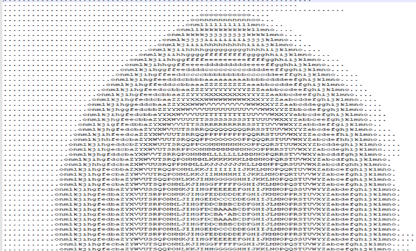
}Some of the constants and the loctype enum are defined in common.h. The map itself is built up by adding extra points to each land point and sea point. I’ve defined an array of points in data.h that has 35 rings of points. Well they’re more squares than rings. That text file shown in the image is what these rings are derived from. I’ve translated all the points into 35 sets of X,Y offsets in data.h.
These points get added in layers. Starting with the first layer which has 8 points in it around the centre – that’s the A’s in the image, the next layer has 12 B’s and 4 C’s in it and so on.
But I only add a land or sea point if the spot its going into is empty; once it is defined as sea or land it can never change. So sea points and land points bump up against each other as these ‘circles’ expand and you get coasts and all sorts of interesting shapes. After that I fill in all empty spaces as sea, and the count up the connected land and sea squares.
If there are any tiny seas, i.e. less than 5 squares area they get filled in as land and any land point that isn’t surrounded by at least 3 other land point gets sunk. Then so long as there are the right number of continents and the total land squares is between 1500 and 1800, the map is accepted. If not a new one is generated. Adjusting the number of initial land and sea points helps to generate more acceptable maps.